Several weeks ago, as part of my goal to get video footage of the River Adur as much as possible up to both of its sources, I visited the village of Ashurst in West Sussex. From there I walked along a public footpath to the river and flew my drone up and down the river. It turned out that there was way too much wind for the drone, so I didn’t get as much usable footage as I was hoping.
But I really liked that little village, and so got some footage and photos both from the ground and from my drone. This seemed to be an excellent place to tell my subscribers about, so here it is: Ashurst Village & The Adur.
We recently spent a week and a half in Devon, and while I’m working on at least two videos concerning what we found there, I thought I would put out a short video showing some of the drone footage I’ve gotten on various occasions. Since aerial photos and videos can show what one is telling about much better sometimes, I’ve made some efforts to learn how to use the two higher-quality drones I now have.
Yesterday we were in the town of Worthing doing a bit of shopping and other errands, and by the end of the day the British Bride was not very keen on cooking dinner (note that I do my fair share of meal prep!) so she decided we would pick up fish and chips at one of the “chip shops” in a neighboring village. There’s a chip shop in our own village, but unfortunately their chips are, in her words, rubbish. I’ve tried them, and she’s right!
Parenthetically, just in case you’re a Yank like me and are unfamiliar with British terminology, “chips” are “french fries”. And what we call “chips” (potato chips) are called “crisps” here in England.
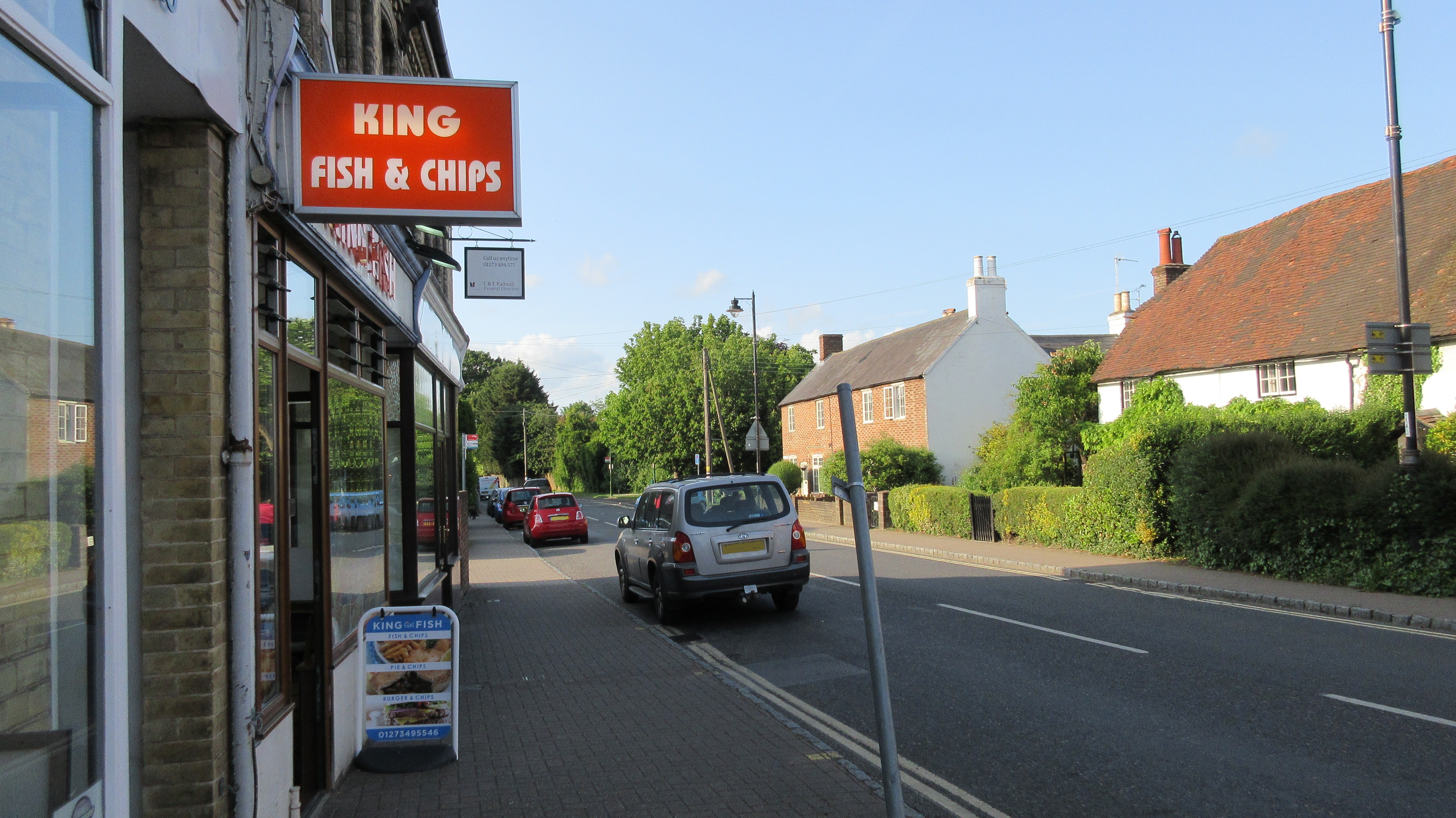
So we popped in at King Fish and Chips in Henfield. We’ve been here before and they make good food.
Like most chip shops, this is for “take out” only
Henfied is a cute little village, although it’s not quite as bucolic as others, being that a semi-major road passes through it (the A2037). It’s quite on the track between Worthing and the towns northwards, so it can get busy at certain times during the day.
Here’s a short video of the traffic of Henfield in the late afternoon:
Traffic down the A2037 around 5:30 pm. Notice how the cars are driving on the left! That’s the custom in the United Kingdom.
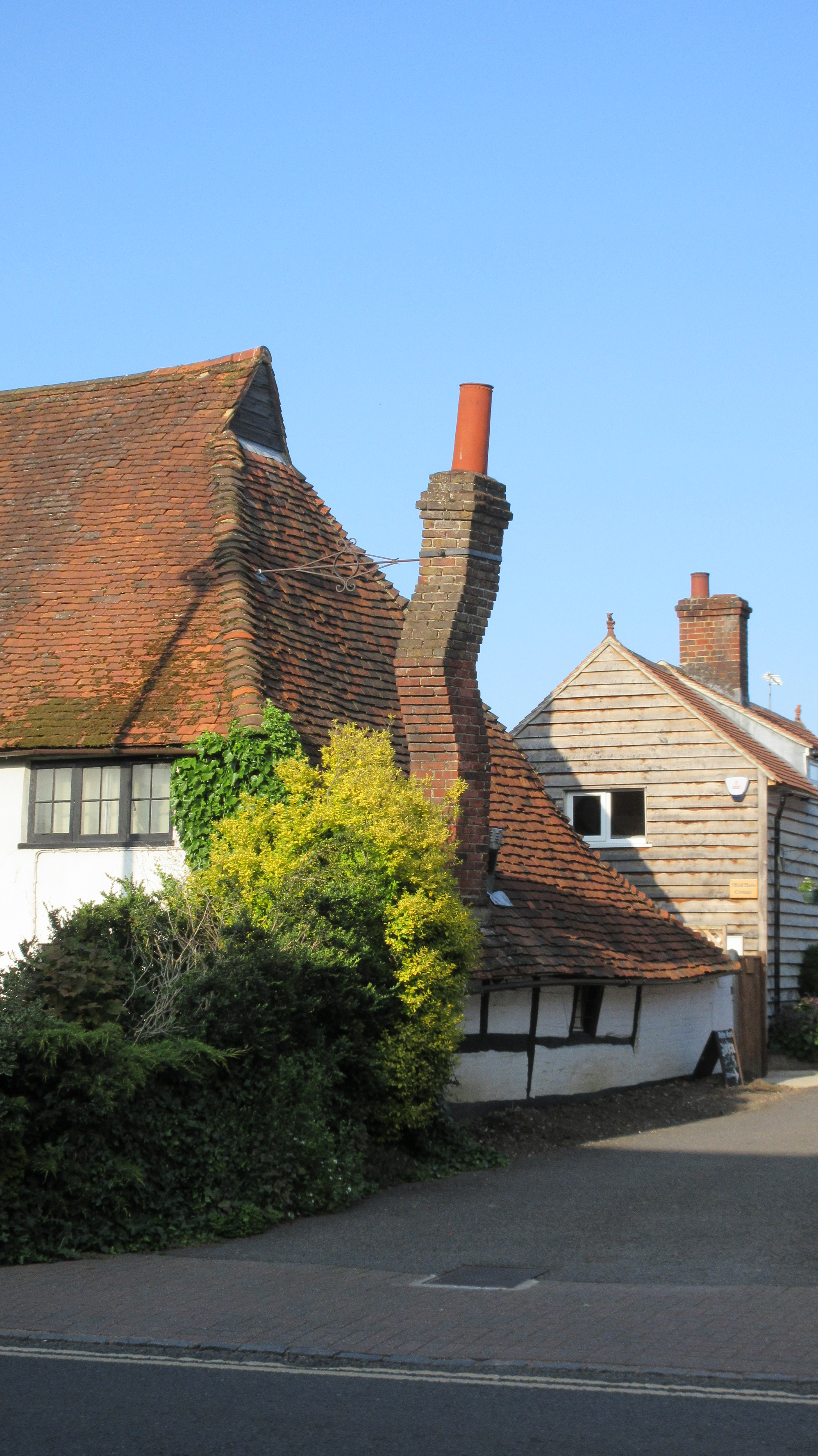
Since the shop has limited seating, we went outside to enjoy the fresh air and the ambiance of the village. While we were communing with the traffic flowing along the road, waiting for our order to be completed I noticed a cottage on the opposite side of the street with a VERY odd brick chimney! I wondered if this had been made this way deliberately, but of course it had to have been. It actually curves in two horizontal directions, not just one. I didn’t notice the additional curve until we were driving away, too late to get a better photo!
Whoever built this chimney must have gotten quite a kick out of imagining the startlement that future generations would get upon noticing this for the first time!
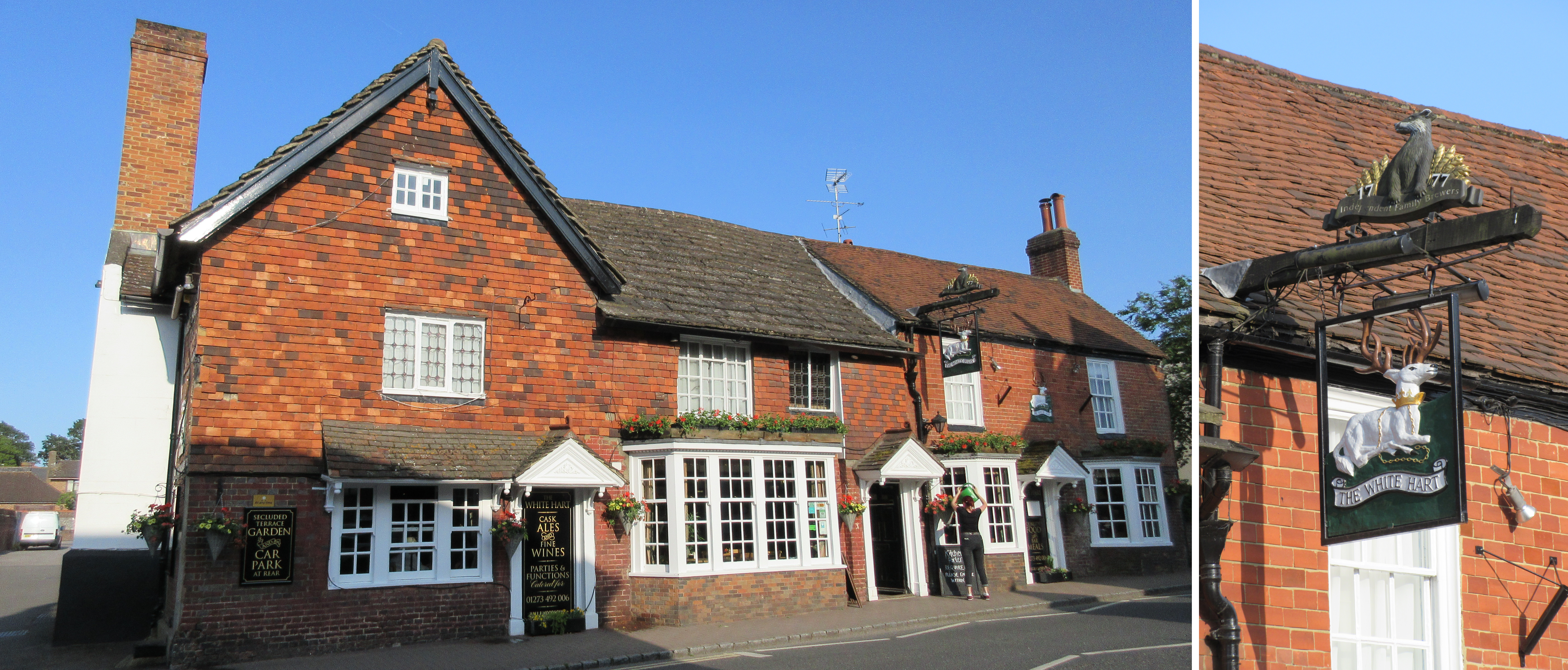
Right next door to the cottage with the sinuous chimney is The White Hart, a really classic English pub! I haven’t been inside yet, but when I do I will be sure to get some photos — even better I’ll sample the food! In case you’re wondering if they are misspelling “heart” on purpose, or if it was just the way they spelled it back in 1777 when the pub was opened, that would be a “No.” “Hart” is actually an old English word for “stag deer”, which you can see in the pub’s sign of business.
If you’re not familiar with the British Isles, this pub name is extremely common, in fact the 5th most popular pub name, possibly because of the wonderment that people would have greeted the discovery of an albino deer, a very rare phenomenon indeed. But more likely it is due to the white hart being the personal badge of King Richard II.
” The historical White Hart Henfield dates from the 16th century and is a classic oak-beamed pub with a wealth of detail that will delight lovers of genuine English architecture. ” — From the website of Henfield’s White Hart.
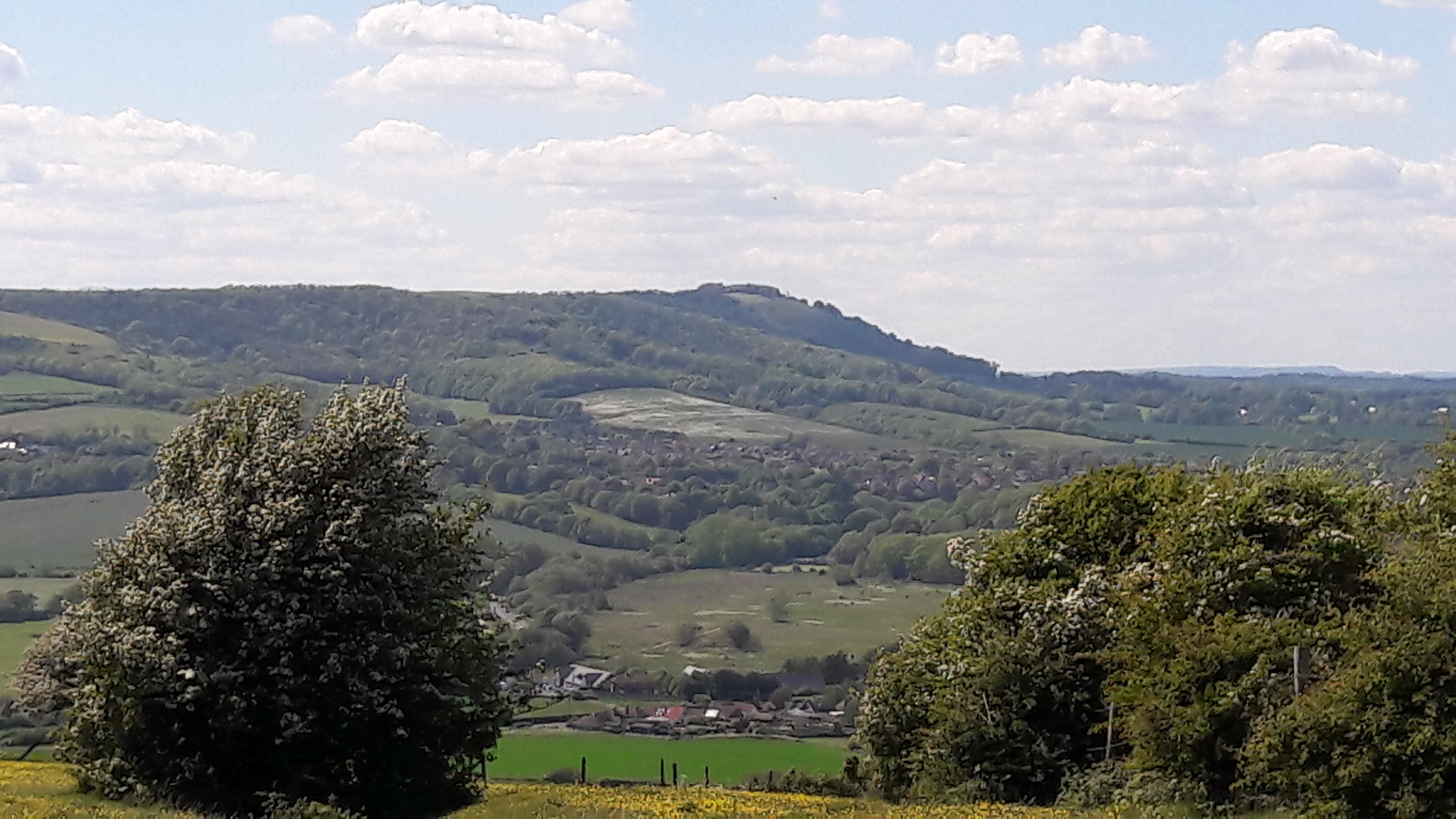
A few days ago I was out at Beeding Hill in West Sussex testing my Hubsan H501S quadcopter to see if I could determine why it was malfunctioning. It appears to be an antenna problem, by the way. But I got a nice shot of the view from Beeding Hill across to Chanctonbury Hill. The major geographic feature between Beeding and Chanctonbury is the Adur Valley, through which the River Adur flows on its way to the English Channel.
A View from Beeding Hill across the Adur Valley to Chanctonbury Hill
There’s nothing particularly special about Beeding Hill, by the way, so there won’t be a Yank in Sussex video forthcoming about it, but Chanctonbury is another matter! Chanctonbury Hill features a prehistoric structure called the Chanctonbury Ring. The Ring is a late Bronze or early Iron age hill fort — but whether it was originally intended as a defensive, religious, or agricultural structure is unknown. Although it has apparently been used for all three purposes over the 2,700-ish years of its existence, it was essentially abandoned as a purposeful structure sometime around 400 CE.
The probable reason why there’s a fort on the hill is because of the hill’s evident prominence: you can see it from everywhere — it rather stands out. As you can see, there is a copse of trees on the hill, but they haven’t always been there. They arrived as a personal project of a certain 16-year old young man, Charles Goring, whose family owned (and still owns) the land the Ring sits on. Charles wanted to beautify the site, so in 1760 he planted a ring of beech trees just inside and outside the rampart of the hill fort. It was this ring of trees that gave the site its name, by the way, and not the hill fort’s rampart.
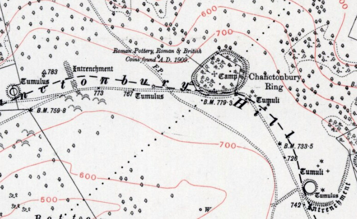
About 150 years later the Goring family decided to plant beech trees in the interior of the hill fort. Which actually ended up being somewhat fortunate, since during preparations for planting they discovered large quantities of Romano-British pottery and building rubble, which prompted the first archaeological excavation of the hill fort. In the course of the excavation two Roman temples were uncovered within the ramparts of the fort! There have been further archaeological investigations at the site since that day.
Some time this summer I will be climbing that hill in order to take videos and photographs of the site, and thus in a few months time there will be A Yank In Sussex video about Chanctonbury Hill on my YouTube channel. I’m looking forward to working on it!
Map of Chanctonbury Hill and Ring from a 1934 Ordnance Survey Map